June 26, 2025
In recent years, electric utilities have found themselves navigating a complex terrain of rising energy demand, aging infrastructure, and increasingly volatile weather conditions. Amid these challenges, the importance of maintaining a resilient, safe, and efficient distribution network has never been more critical.
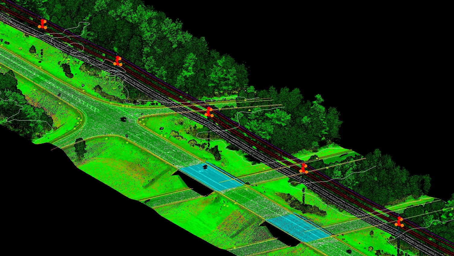
One technology has emerged as a quiet yet powerful force in this transformation: LiDAR (Light Detection and Ranging). When integrated with modern GIS (Geographic Information Systems), LiDAR enables utilities to visualize their networks not just in maps or schematics, but in rich, three-dimensional reality.
This article explores how LiDAR is being applied to core aspects of powerline distribution—particularly in vegetation management, sag and clearance analysis, pole loading, asset mapping, damage assessment, and right-of-way management.
Vegetation remains one of the most persistent threats to overhead powerlines. Tree limbs growing too close to conductors are a leading cause of outages, wildfires, and even fatalities. Traditionally, utilities have relied on manual inspections and periodic trimming, often operating on fixed schedules that don’t reflect real-world conditions.
LiDAR changes this equation. By scanning the terrain and canopy with millions of laser pulses, it captures incredibly accurate data on tree height, density, and—most importantly—proximity to conductors. Utilities can now identify encroachments with centimeter-level precision and prioritize trimming where the risk is highest.
The result? A shift from reactive to predictive vegetation management, with fewer outages and more efficient use of maintenance budgets.
As conductors heat up, they expand and sag. On hot days or during peak loads, the risk of wires drooping dangerously close to the ground or nearby objects increases. It’s a subtle, physics-driven challenge—but one with serious implications for safety and compliance.
LiDAR enables utilities to measure actual sag and clearance across the entire length of a distribution line. It captures the topography, structural supports, and conductors themselves in 3D, allowing engineers to detect where ground clearances are insufficient or where terrain poses a hidden risk.
Rather than relying on design assumptions, utilities can now model how their lines behave in the real world, under real conditions. This data is indispensable for ensuring regulatory compliance and public safety.
Every pole in a distribution system supports a delicate balance of mechanical forces—conductors, crossarms, transformers, and environmental stresses. Over time, poles may lean, rot, or become overloaded, particularly as new equipment is added without a full assessment of capacity.
Using LiDAR, engineers can capture a pole’s height, tilt, load configuration, and the spatial arrangement of attached components. When this data is fed into structural analysis models, it provides a much more accurate picture of how each pole is performing—and when it might be at risk of failure.
In the context of storm preparation or system upgrades, this capability can be the difference between strategic reinforcement and costly outages.
Keeping track of thousands of assets scattered across vast service areas is a perennial challenge for utilities. GPS tagging and field surveys have improved the situation, but LiDAR goes further—it enables automated detection and classification of poles, wires, insulators, and more.
By integrating LiDAR scans with GIS platforms, utilities can build detailed, real-time maps of their infrastructure—often referred to as digital twins. These are more than visual tools; they’re functional systems that support maintenance planning, outage response, and long-term investment decisions.
In an era of data-driven decision-making, a reliable asset inventory is not just helpful—it’s foundational.
When storms, wildfires, or other disasters strike, time is of the essence. Traditionally, utilities dispatched crews on foot or by vehicle to assess damage—often working blind and under hazardous conditions.
LiDAR provides a safer, faster alternative. By comparing “before” and “after” scans, utilities can quickly identify where poles have fallen, where vegetation has shifted, or where infrastructure has been compromised. Drones equipped with LiDAR make this process even faster and more flexible, reaching areas that are otherwise inaccessible.
This capability dramatically shortens restoration times and improves safety for inspection crews, all while reducing downtime for customers.
The corridors that house distribution lines—known as rights-of-way—are often affected by encroachments, unauthorized construction, or changing land use. Managing them requires not only legal clarity but spatial accuracy.
With LiDAR, utilities can map the exact boundaries and conditions of their ROW in 3D, monitoring for changes over time. Whether it’s a new building too close to a line or natural growth infringing on access paths, LiDAR enables early detection and informed enforcement.
This reduces legal disputes, improves safety, and ensures that crews can always access the network when needed.
As utility networks evolve, the need for accurate, actionable spatial intelligence will only grow. LiDAR provides more than just pretty pictures—it offers a new lens through which to manage complexity, risk, and change.
By adopting LiDAR across core distribution functions, utilities position themselves to not only meet today’s challenges but also to lead the energy transition with confidence.